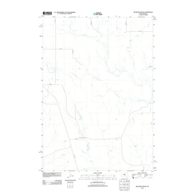
2012 Map of Big Bend Dam NE
USGS Topo · Published 2012About this map
Wolf Creek and the meandering channels of the W Fork Elm Creek define the drainage patterns of this central South Dakota landscape. The map centers on the Knippling Ranch, located along 223rd Street and 344th Avenue, which serves as a primary marker of the region's agricultural and ranching layout. The topography is dominated by subtle seasonal waterways including Elm Creek and Sand Creek, which cut across a strictly defined section-line road grid. The presence of these named ranching landmarks and local road identifiers like 341st Avenue and 217th Street provides a detailed view of the rural infrastructure in Buffalo County during the early 21st century, illustrating how contemporary land use continues to follow historical survey lines.
Find a feature on this map
15 named features on this map. Tap any name to fly to it.
Don’t see what you’re looking for? This feature index may not catch every label — zoom into the map to look around manually.
Map Details
Editions of this 2012 Big Bend Dam NE Map
This is the sole edition of this map. No revisions or reprints were ever made.
Other maps of this area

1953 · Huron
USGS Topo · 1:250,000

1954 · Huron
USGS Topo · 1:250,000

1966 · Big Bend Dam NE
USGS Topo · 1:24,000

1966 · Big Bend Dam SE
USGS Topo · 1:24,000

1966 · Stephan
USGS Topo · 1:24,000

1966 · Big Bend Dam
USGS Topo · 1:24,000

1973 · Miller Dale Colony SW
USGS Topo · 1:24,000

1973 · Big Bend Dam 4 NW
USGS Topo · 1:24,000

1973 · Macs Corner SE
USGS Topo · 1:24,000
1973 · Big Bend Dam 4 SW
USGS Topo · 1:24,000
Featured Places
- Arlington Township, SD
- Fort Thompson District, SD
- Grey Hill East Township, Fort Thompson District
- Buffalo County, SD
- Hand County, SD