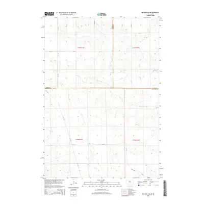
2015 Map of Big Bend Dam NE
USGS Topo · Published 2015About this map
The rolling plains of central South Dakota are defined by a network of drainage channels that converge where Buffalo, Hyde, and Hand counties meet. Elm Cr and its tributary W Fork Elm Cr meander through the northern and central sections, carving subtle relief into the landscape. The geography is strictly organized by the Public Land Survey System, with township boundaries for t109n r71w, t109n r70w, t108n r71w, and t108n r70w dictating the placement of rural section lines. Local transport follows this rigid grid along corridors such as 341st Ave and 220th St. To the south, Wolf Cr provides additional drainage, while Lees Blvd cuts a diagonal path across the western sections, diverging from the standard north-south section roads. This survey illustrates the sparse, agrarian layout of the region, where watercourses like Sand Cr remain the primary natural landmarks amidst a landscape shaped by rural infrastructure.
Find a feature on this map
22 named features on this map. Tap any name to fly to it.
Don’t see what you’re looking for? This feature index may not catch every label — zoom into the map to look around manually.
Map Details
Editions of this 2015 Big Bend Dam NE Map
This is the sole edition of this map. No revisions or reprints were ever made.
Other maps of this area

1953 · Huron
USGS Topo · 1:250,000

1954 · Huron
USGS Topo · 1:250,000

1966 · Big Bend Dam NE
USGS Topo · 1:24,000

1966 · Big Bend Dam SE
USGS Topo · 1:24,000

1966 · Stephan
USGS Topo · 1:24,000

1966 · Big Bend Dam
USGS Topo · 1:24,000

1973 · Miller Dale Colony SW
USGS Topo · 1:24,000

1973 · Big Bend Dam 4 NW
USGS Topo · 1:24,000

1973 · Macs Corner SE
USGS Topo · 1:24,000
1973 · Big Bend Dam 4 SW
USGS Topo · 1:24,000
Featured Places
- Arlington Township, SD
- Fort Thompson District, SD
- Grey Hill East Township, Fort Thompson District
- Buffalo County, SD
- Hand County, SD