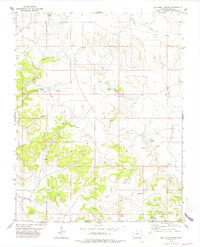
1978 Map of Big Hole Canyon
USGS Topo · Published 1979About this map
The High Plains landscape of southeastern Colorado meets the Oklahoma border in this late-1970s survey, defined by the intricate drainages and canyon systems that break the mesa country. Big Hole and its namesake Big Hole Spring serve as central landmarks in a region where water sources are the primary indicators of human activity and history. The terrain is marked by numerous family-named or topographical springs such as Regnar Spring, Trujillo Spring, and Hatfield Spring, which likely served as vital hubs for cattle ranching operations on both sides of the state line. In the southern portion of the sheet, the Little Black Mesa rises above the North Fork Carrizo Creek, illustrating the transition from open prairie to more complex rimrock topography. Narrow canyons like Whitby Canyon and Pat Canyon cut through the landscape, revealing the remote and cattle-driven character of this borderland.
Find a feature on this map
23 named features on this map. Tap any name to fly to it.
Don’t see what you’re looking for? This feature index may not catch every label — zoom into the map to look around manually.
Map Details
Editions of this 1978 Big Hole Canyon Map
This is the sole edition of this map. No revisions or reprints were ever made.
Other maps of this area

1891 · Springfield
USGS Topo · 1:125,000

1892 · Mt Carrizo
USGS Topo · 1:125,000

1893 · Springfield
USGS Topo · 1:125,000

1954 · Dalhart
USGS Topo · 1:250,000

1955 · La Junta
USGS Topo · 1:250,000

1958 · La Junta
USGS Topo · 1:250,000

1958 · Dalhart
USGS Topo · 1:250,000

1962 · Dalhart
USGS Topo · 1:250,000

1968 · La Junta
USGS Topo · 1:250,000

1968 · Kenton
USGS Topo · 1:24,000