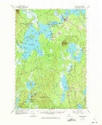
1963 Map of Big Lake
USGS Topo · Published 1975About this map
Indian Township and the surrounding plantations and unorganized territories of Washington County are defined by a complex labyrinth of freshwater lakes and streams. The settlement at Princeton serves as the primary hub, situated where Lewy Lake and Long Lake meet the The Narrows. Further south, the map reveals isolated camps and landings such as Old Crawford Camp and Red Beach Landing, which indicate the region's reliance on the waterways for transport and seasonal residency.
Find a feature on this map
137 named features on this map. Tap any name to fly to it.
Don’t see what you’re looking for? This feature index may not catch every label — zoom into the map to look around manually.
Map Details
Editions of this 1963 Big Lake Map
4 editions found
Other maps of this area

1929 · Calais
USGS Topo · 1:48,000

1932 · Calais
USGS Topo · 1:62,500

1940 · Waite
USGS Topo · 1:62,500

1940 · Kellyland
USGS Topo · 1:62,500

1941 · Scraggly Lake
USGS Topo · 1:62,500

1941 · Wesley
USGS Topo · 1:62,500

1941 · Gardner Lake
USGS Topo · 1:62,500

1941 · Tug Mountain
USGS Topo · 1:62,500

1941 · Big Lake
USGS Topo · 1:62,500

1941 · Wabassus Lake
USGS Topo · 1:62,500