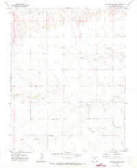
1971 Map of Big Rock Grange
USGS Topo · Published 1973About this map
Big Rock Grange stands as the primary community landmark in this rural corner of Baca County, Colorado. The landscape is defined by the drainage patterns of North Horse Creek and South Horse Creek, which carve winding paths across the high plains. A significant industrial feature, a long-distance Pipeline, cuts vertically through the eastern sections of the quadrangle, reflecting the region's energy infrastructure during the early 1970s. The presence of multiple Wells and a Gravel Pit indicate the essential local economies of water management and material extraction. This map illustrates a transition between open range and managed rural tracts, with Sand Creek crossing the northern portion through relatively level terrain before the land begins to rise and roll toward the surrounding plateaus.
Find a feature on this map
10 named features on this map. Tap any name to fly to it.
Don’t see what you’re looking for? This feature index may not catch every label — zoom into the map to look around manually.
Map Details
Editions of this 1971 Big Rock Grange Map
This is the sole edition of this map. No revisions or reprints were ever made.
Other maps of this area

1891 · Springfield
USGS Topo · 1:125,000

1892 · Two Butte
USGS Topo · 1:125,000

1893 · Two Butte
USGS Topo · 1:125,000

1893 · Springfield
USGS Topo · 1:125,000

1955 · La Junta
USGS Topo · 1:250,000

1958 · La Junta
USGS Topo · 1:250,000

1968 · La Junta
USGS Topo · 1:250,000
1971 · Horse Creek Springs
USGS Topo · 1:24,000
1971 · Mc Endree Ranch
USGS Topo · 1:24,000
1971 · Two Buttes Reservoir
USGS Topo · 1:24,000