1936 Map of Big Sandy
USGS Topo · Published 1936About this map
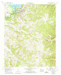
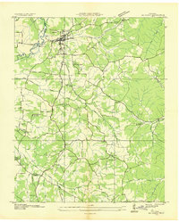
Big Sandy sits at the junction of the Louisville and Nashville railroad and the Big Sandy River in this 1936 survey, which details a landscape of small rural communities along the Henry Benton county line. The map reveals an intricate network of drainage systems, such as the Ramble Creek Drainage Ditch and Beasley Ditch, reflecting the local efforts to manage the water-rich bottomlands. These watercourses are flanked by numerous centers of community life, including McCarthy Chapel, Baker Chapel, and Ramble Creek Ch.
Find a feature on this map
60 named features on this map. Tap any name to fly to it.
Don’t see what you’re looking for? This feature index may not catch every label — zoom into the map to look around manually.
Map Details
Editions of this 1936 Big Sandy Map
This is the sole edition of this map. No revisions or reprints were ever made.
Historical Maps of Big Sandy Through Time
7 maps found