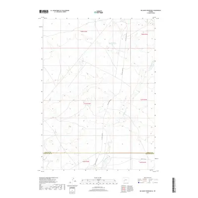
2017 Map of Big Sandy Reservoir SE
USGS Topo · Published 2017About this map
Little Sandy Cr defines the drainage of this High Plains landscape as it flows through the northeast and southeast portions of this 2017 survey. The territory is dominated by open range and significant historical travel corridors, including the Sublette Cutoff in the southeastern corner, a route deeply tied to westward expansion. Water management is evident near the northern boundary at Little Sandy Reservoir Number 2, which serves as a vital point in this arid region. The map captures the meeting of the Sublette Co Sweetwater Co line, illustrating the administrative boundaries that bisect the sagebrush and grazing lands. Regional transit is maintained by unimproved roads like Big Sandy Elkhorn Rd and Parson-Little Sandy Rd, which connect remote sections of the townships.
Find a feature on this map
12 named features on this map. Tap any name to fly to it.
Don’t see what you’re looking for? This feature index may not catch every label — zoom into the map to look around manually.
Map Details
Editions of this 2017 Big Sandy Reservoir SE Map
This is the sole edition of this map. No revisions or reprints were ever made.
Other maps of this area

1955 · Lander
USGS Topo · 1:250,000

1958 · Lander
USGS Topo · 1:250,000

1958 · Parting of the Ways
USGS Topo · 1:62,500

1958 · Essex Mountain
USGS Topo · 1:62,500

1958 · Tule Butte
USGS Topo · 1:24,000

1958 · Parting of the Ways
USGS Topo · 1:24,000

1961 · Lander
USGS Topo · 1:250,000

1968 · Eden Reservoir East
USGS Topo · 1:24,000
1968 · Eden Reservoir West
USGS Topo · 1:24,000

1969 · Leckie Reservoir
USGS Topo · 1:24,000