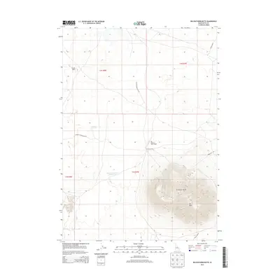
2013 Map of Big Southern Butte
USGS Topo · Published 2013About this map
Big Southern Butte dominates this high-desert Idaho landscape, rising sharply from the surrounding plains. The prominence of this volcanic landmark is a central focus for the area, which also features the smaller Coyote Butte and Big Butte nearby. Human presence in this isolated terrain is marked by remote outposts such as Frenchmans Cabin and the Big Southern Butte Airport, a landing strip positioned near the base of the mountain. Water management is critical in this arid environment, evidenced by the presence of Big Butte Reservoir and Big Butte Reservoir Number Two, along with high-elevation sources like Frenchmans Spring and Webb Spring. The road network consists primarily of unpaved routes, including Frenchman Rd and Cow Pasture Rd, which connect these water sources and remote landmarks across the expanse of Butte County.
Find a feature on this map
19 named features on this map. Tap any name to fly to it.
Don’t see what you’re looking for? This feature index may not catch every label — zoom into the map to look around manually.
Map Details
Editions of this 2013 Big Southern Butte Map
This is the sole edition of this map. No revisions or reprints were ever made.
Other maps of this area

1955 · Idaho Falls
USGS Topo · 1:250,000

1958 · Idaho Falls
USGS Topo · 1:250,000

1972 · Quaking Aspen Butte
USGS Topo · 1:24,000

1972 · Arco Hills SE
USGS Topo · 1:24,000

1972 · Big Southern Butte
USGS Topo · 1:24,000

1972 · Butte City
USGS Topo · 1:24,000

1972 · Sunset Lake
USGS Topo · 1:24,000

1972 · Serviceberry Butte
USGS Topo · 1:24,000

1973 · Scoville
USGS Topo · 1:24,000

1973 · Rock Butte
USGS Topo · 1:24,000