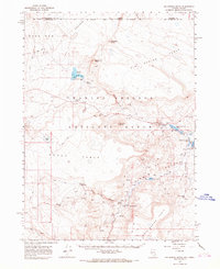
1966 Map of Big Spring Butte
USGS Topo · Published 1968About this map
The Charles Sheldon Antelope Range dominates this mid-1960s landscape along the remote Nevada-Oregon border, centered in the high desert of Humboldt County. The map documents a land defined by specialized desert infrastructure and resource extraction, including the Virgin Mine and the Rainbow Ridge Mine in the south, alongside numerous unnamed Prospect sites. Water management is critical in this arid environment, evidenced by the presence of Big Spring Res, several Flowing Wells, and Jacobs Waterhole. Human presence is concentrated at seasonal or operational hubs like McKenney Camp and Gooch Camp, while the Virgin Valley Campground and its nearby Landing Strip indicate the area's role in wildlife management and recreation. The geography transitions from the flat expanses of Big Spring Table and Gooch Table down into the complex drainage of Virgin Canyon.
Find a feature on this map
46 named features on this map. Tap any name to fly to it.
Don’t see what you’re looking for? This feature index may not catch every label — zoom into the map to look around manually.
Map Details
Editions of this 1966 Big Spring Butte Map
2 editions found
Other maps of this area

1886 · Disaster
USGS Topo · 1:250,000

1889 · Long Valley
USGS Topo · 1:250,000

1893 · Disaster
USGS Topo · 1:250,000

1954 · Vya
USGS Topo · 1:250,000

1955 · Adel
USGS Topo · 1:250,000

1957 · Adel
USGS Topo · 1:250,000

1958 · Vya
USGS Topo · 1:250,000

1958 · Adel
USGS Topo · 1:250,000

1962 · Vya
USGS Topo · 1:250,000

1962 · Adel
USGS Topo · 1:250,000