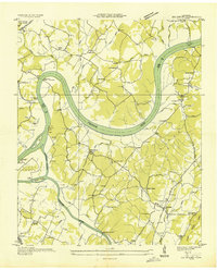
1935 Map of Big Spring
USGS Topo · Published 1935About this map
The Tennessee River snakes through the heart of this 1935 quadrangle, defining the boundary between Meigs and Rhea counties. The landscape is marked by a transit-dependent economy where numerous river crossings like Cotton Port Ferry, Armstrong Ferry, and Bunker Hill Ferry provide vital links between rural communities. Along the western banks, educational and religious life is anchored by institutions such as William Jennings Bryan University and Salem Ch, while the eastern side near the community of Big Spring is dotted with local landmarks like Bergers Chapel and Mt Carmel Ch.
Find a feature on this map
110 named features on this map. Tap any name to fly to it.
Don’t see what you’re looking for? This feature index may not catch every label — zoom into the map to look around manually.
Map Details
Editions of this 1935 Big Spring Map
This is the sole edition of this map. No revisions or reprints were ever made.
Other maps of this area

1886 · Cleveland
USGS Topo · 1:125,000

1887 · Kingston
USGS Topo · 1:125,000

1888 · Chattanooga
USGS Topo · 1:125,000

1891 · Kingston
USGS Topo · 1:125,000

1892 · Pikeville
USGS Topo · 1:125,000

1892 · Cleveland
USGS Topo · 1:125,000

1893 · Chattanooga
USGS Topo · 1:125,000

1893 · Kingston
USGS Topo · 1:125,000

1895 · Cleveland
USGS Topo · 1:125,000

1895 · Pikeville
USGS Topo · 1:125,000