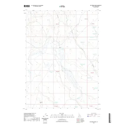
2020 Map of Big Springs Ranch
USGS Topo · Published 2020About this map
Big Springs Ranch sits within a landscape defined by an intricate network of drainage basins and water management in Owyhee County. The terrain is marked by the prominent Big Springs Butte to the southwest and the expansive Antelope Flat in the northeast corner. This high desert environment is heavily engineered for water retention, featuring a sequence of numbered catchments including the Pole Cr Reservoir Number One series and several Dry Cr Reservoir sites. Waterways like Camas Cr and Big Springs Cr wind through the township boundaries of T9S, T10S, and T11S. The primary transit route through this remote ranching territory is Battle Creek Rd, which follows the path of Battle Creek and Dry Cr, connecting the various reservoirs and springs that sustain the local livestock operations.
Find a feature on this map
28 named features on this map. Tap any name to fly to it.
Don’t see what you’re looking for? This feature index may not catch every label — zoom into the map to look around manually.
Map Details
Editions of this 2020 Big Springs Ranch Map
This is the sole edition of this map. No revisions or reprints were ever made.
Other maps of this area

1955 · Jordan Valley
USGS Topo · 1:250,000

1957 · Jordan Valley
USGS Topo · 1:250,000

1958 · Jordan Valley
USGS Topo · 1:250,000
1972 · Frying Pan Basin
USGS Topo · 1:24,000
1972 · Big Springs Ranch
USGS Topo · 1:24,000
1972 · Crab Spring Butte
USGS Topo · 1:24,000
1972 · Snow Creek
USGS Topo · 1:24,000
1972 · Clover Mtn
USGS Topo · 1:24,000
1972 · Lost Valley
USGS Topo · 1:24,000
1973 · Wagon Box Basin
USGS Topo · 1:24,000