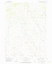
1972 Map of Big Springs Ranch
USGS Topo · Published 1975About this map
The high plateau of Owyhee County is defined by its seasonal water management and ranching infrastructure, as seen in this early 1970s survey. Big Springs Ranch sits at the heart of a landscape dominated by drainage systems like Camas Creek, Pole Creek, and Dry Creek. The area’s livestock-focused economy is evidenced by a complex network of man-made catchments, including Antelope Flat Reservoir, Sagebrush Flat Reservoir, and a numbered series of reservoirs such as Pole Creek Reservoir No 1 and West Rim Reservoir No 1.
Find a feature on this map
26 named features on this map. Tap any name to fly to it.
Don’t see what you’re looking for? This feature index may not catch every label — zoom into the map to look around manually.
Map Details
Editions of this 1972 Big Springs Ranch Map
This is the sole edition of this map. No revisions or reprints were ever made.
Other maps of this area

1955 · Jordan Valley
USGS Topo · 1:250,000

1957 · Jordan Valley
USGS Topo · 1:250,000

1958 · Jordan Valley
USGS Topo · 1:250,000
1972 · Frying Pan Basin
USGS Topo · 1:24,000
1972 · Crab Spring Butte
USGS Topo · 1:24,000
1972 · Snow Creek
USGS Topo · 1:24,000
1972 · Clover Mtn
USGS Topo · 1:24,000
1972 · Lost Valley
USGS Topo · 1:24,000
1973 · Wagon Box Basin
USGS Topo · 1:24,000

1973 · Hurry Up Creek
USGS Topo · 1:24,000