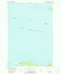
1964 Map of Big Stone Bay
USGS Topo · Published 1989About this map
Wilderness State Park anchors the southern coastline of this 1964 survey, where the terrestrial landscape of Emmet County meets the expansive waters of Lake Michigan. The map details a low-lying, swampy coastal environment defined by prominent features such as Waugoshance Point and the sheltered waters of Sturgeon Bay and Goose Bay. These shorelines represent a preserved natural frontier, where the land-to-water transition is marked by intricate depth curves and soundings.
Find a feature on this map
13 named features on this map. Tap any name to fly to it.
Don’t see what you’re looking for? This feature index may not catch every label — zoom into the map to look around manually.
Map Details
Editions of this 1964 Big Stone Bay Map
2 editions found
Other maps of this area

1931 · Moran NE
USGS Topo · 1:31,680

1948 · Moran NE
USGS Topo · 1:31,680

1948 · Moran NW
USGS Topo · 1:31,680

1955 · Cheboygan
USGS Topo · 1:250,000

1958 · Cheboygan
USGS Topo · 1:250,000

1958 · Cross Village
USGS Topo · 1:62,500

1958 · Pellston
USGS Topo · 1:62,500

1964 · Big Stone Bay
USGS Topo · 1:24,000
1964 · Moran
USGS Topo · 1:24,000
1964 · Pointe Aux Chenes
USGS Topo · 1:24,000