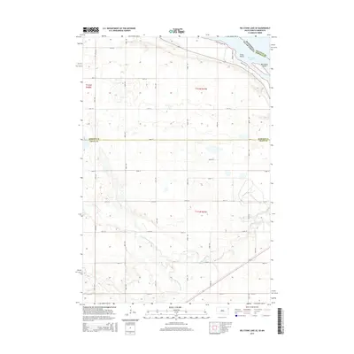
2015 Map of Big Stone Lake SE
USGS Topo · Published 2015About this map
The Big Stone Lake shoreline marks the northeastern boundary of this landscape, where the waters divide Big Stone and Roberts counties. This area is defined by the convergence of the Whetstone River system, featuring the N Fork and S Fork Whetstone River as they move toward the state line. The map captures the agricultural grid of Grant County as it transitions into the lake environment, highlighted by localized features like Goose Island and Manhattan Island. Local land use is reflected in specific road names such as Frevert Farm Rd and Eagleview Lake Rd, which provide access to the lake's edge. The documentation of Section, Township, and Range lines, such as t121n r47w, offers a precise framework for researchers tracing specific parcels of land within this riverine and lacustrine geography.
Find a feature on this map
30 named features on this map. Tap any name to fly to it.
Don’t see what you’re looking for? This feature index may not catch every label — zoom into the map to look around manually.
Map Details
Editions of this 2015 Big Stone Lake SE Map
This is the sole edition of this map. No revisions or reprints were ever made.
Other maps of this area

1953 · Ortonville
USGS Topo · 1:62,500

1953 · Bellingham
USGS Topo · 1:62,500

1953 · Milbank
USGS Topo · 1:250,000

1954 · Big Stone Lake
USGS Topo · 1:62,500

1958 · Milbank
USGS Topo · 1:250,000

1971 · Big Stone Lake East
USGS Topo · 1:24,000

1971 · Big Stone Lake West
USGS Topo · 1:24,000

1971 · Rosen
USGS Topo · 1:24,000

1971 · Big Stone Lake SE
USGS Topo · 1:24,000

1971 · Big Stone Lake SW
USGS Topo · 1:24,000