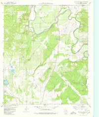
1979 Map of Big Valley South
USGS Topo · Published 1980About this map
The Colorado River carves a winding path through the borderlands of San Saba and Mills counties, anchoring a landscape of cattle ranching and scattered family homesteads. The Big Valley region is defined by its dramatic topographic relief, where the Mauldin Hills and prominent peaks like Wildhorse Mountain and Round Mountain rise above the river bottomlands. This 1970s survey illustrates a rural Texas economy still tied to the land and water, featuring several creek systems including Horse Creek, Rocky Creek, and the three prongs—North Prong, Middle Prong, and South Prong.
Find a feature on this map
27 named features on this map. Tap any name to fly to it.
Don’t see what you’re looking for? This feature index may not catch every label — zoom into the map to look around manually.
Map Details
Editions of this 1979 Big Valley South Map
This is the sole edition of this map. No revisions or reprints were ever made.
Other maps of this area

1885 · San Saba
USGS Topo · 1:125,000

1894 · San Saba
USGS Topo · 1:125,000

1925 · San Saba 4-a
USGS Topo · 1:48,000

1925 · San Saba 2-a
USGS Topo · 1:48,000

1925 · San Saba 1-c
USGS Topo · 1:48,000

1925 · San Saba 1-b
USGS Topo · 1:48,000

1925 · San Saba 1-d
USGS Topo · 1:48,000

1928 · Goldthwaite
USGS Topo · 1:62,500

1930 · Richland Springs
USGS Topo · 1:62,500

1931 · Bend
USGS Topo · 1:62,500