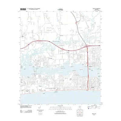
2012 Map of Biloxi
USGS Topo · Published 2012About this map
Tchoutacabouffa River and the Biloxi River converge into the Back Bay of Biloxi, defining a complex coastal landscape of peninsulas and marshes. This 2012 survey illustrates the dense urban expansion of Biloxi and D'Iberville against the Gulf Coast, where local history and modern infrastructure meet. The map traces the historic Beauvoir estate and the Old French Cem, offering clear reference points for genealogists and local historians. North of the bay, the character of the land shifts toward smaller settlements like Wool Market and Cedar Lake, while the waterways remain punctuated by features such as Marsh Island, Goat Island, and Devils Elbow. Military and recreational footprints are prominent, from the sprawling grounds of Keesler Air Force Base to numerous waterfront golf courses and the Biloxi Fishing Piers along the Gulf of Mexico shoreline.
Find a feature on this map
53 named features on this map. Tap any name to fly to it.
Don’t see what you’re looking for? This feature index may not catch every label — zoom into the map to look around manually.
Map Details
Editions of this 2012 Biloxi Map
This is the sole edition of this map. No revisions or reprints were ever made.
Other maps of this area

1953 · Mobile
USGS Topo · 1:250,000

1954 · Vestry
USGS Topo · 1:62,500

1954 · McHenry
USGS Topo · 1:62,500

1954 · Gulfport North
USGS Topo · 1:24,000

1954 · Gulfport South
USGS Topo · 1:24,000

1954 · Ocean Springs
USGS Topo · 1:24,000

1954 · Biloxi
USGS Topo · 1:24,000

1954 · Deer Island
USGS Topo · 1:24,000

1954 · Biloxi
USGS Topo · 1:62,500

1957 · Mobile
USGS Topo · 1:250,000