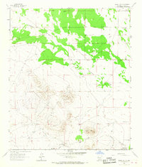
1965 Map of Bisbee Hills
USGS Topo · Published 1967About this map
Burdick Hills and the lower Bisbee Hills dominate this high-desert landscape in Luna County, characterized by a complex network of seasonal drainage patterns and sparse ranching infrastructure. Mapping during the mid-1960s recorded a topography shaped by water management, notably the Miller Gibson Detention Dam No 1 and Miller Gibson Detention Dam No 2, which appear as critical infrastructure in an otherwise arid environment. Ranching operations are the primary markers of human presence, including the Stringer Ranch and Miller Ranch, supported by a series of isolated water sources such as the Porcher Windmill and Seventysix Well. These features, along with the Cassell Cem, provide a glimpse into the family-held lands and livestock economy that defined this region of New Mexico. The terrain is further defined by deep erosional cuts like Seventysix Draw and Bisbee Draw, which channel the infrequent but intense rainfall through the rocky outcrops.
Find a feature on this map
15 named features on this map. Tap any name to fly to it.
Don’t see what you’re looking for? This feature index may not catch every label — zoom into the map to look around manually.
Map Details
Editions of this 1965 Bisbee Hills Map
This is the sole edition of this map. No revisions or reprints were ever made.
Other maps of this area

1899 · Deming
USGS Topo · 1:125,000

1915 · Deming
USGS Topo · 1:125,000

1917 · Hermanas
USGS Topo · 1:62,500

1918 · Hermanas
USGS Topo · 1:62,500

1918 · Victorio
USGS Topo · 1:62,500

1943 · Hermanas
USGS Topo · 1:62,500

1953 · El Paso
USGS Topo · 1:250,000

1954 · Silver City
USGS Topo · 1:250,000

1955 · Douglas
USGS Topo · 1:250,000

1955 · Las Cruces
USGS Topo · 1:250,000