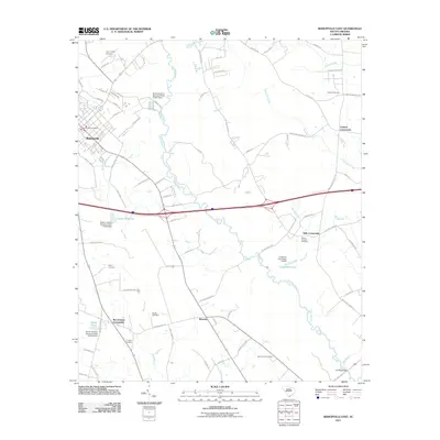
2011 Map of Bishopville East
USGS Topo · Published 2011About this map
Lynches River and the Black River define the watery landscape of eastern Lee County, flowing through a region of lowlands and agricultural crossings. The area is anchored by Bishopville, the county seat, which appears here with its residential grid and the Bishopville Post Office near the western edge. This 2011 survey captures a landscape punctuated by generational landmarks and small crossroads like Wisacky and Kiffs Crossroads.
Find a feature on this map
92 named features on this map. Tap any name to fly to it.
Don’t see what you’re looking for? This feature index may not catch every label — zoom into the map to look around manually.
Map Details
Editions of this 2011 Bishopville East Map
This is the sole edition of this map. No revisions or reprints were ever made.
Other maps of this area

1941 · Spartanburg
USGS Topo · 1:250,000

1953 · Spartanburg
USGS Topo · 1:250,000

1957 · Ashwood
USGS Topo · 1:62,500

1960 · Spartanburg
USGS Topo · 1:250,000

1963 · Spartanburg
USGS Topo · 1:250,000

1964 · Spartanburg
USGS Topo · 1:250,000

1968 · Kellytown
USGS Topo · 1:24,000
1968 · Hartsville South
USGS Topo · 1:24,000
1969 · Lamar
USGS Topo · 1:24,000
1969 · Bishopville East
USGS Topo · 1:24,000