Old Maps of Lee County, South Carolina
Explore 109 old maps of Lee County, spanning from 1920 to today. These high-resolution historic maps reveal how streets, neighborhoods, landmarks, and natural features evolved over time — perfect for genealogy, metal detecting, research, and local history exploration.
What you can do with these maps:
- See how Lee County changed over time: Compare historical maps to modern-day views to trace roads, homesites, rail lines & more.
- View detailed metadata: Each map includes creators, publishers, year, scale, and archive source.
- Overlay maps with satellite & LiDAR: Visualize the past alongside modern tools to explore terrain & human change.
- Trusted historical sources: Maps sourced from the USGS, Library of Congress, and other archives.
- Access maps your way: View online, download high-res files, or order prints for personal or research use.
Start exploring old maps of Lee County to uncover forgotten places, hidden landmarks, and the deep history beneath your feet.
Lee County, SC maps
(109)- 1920 Map of Mayesville
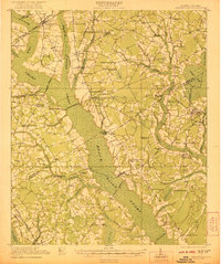
 1920 Mayesville1920 Print · USGSThe rural lowcountry of Sumter and Clarendon counties is captured here in the years following World War I, when the Black River and its dense swamps dictated the pace of local life. Researchers can trace early twentieth-century community life through numerous rural landmarks like Brick Church, Tomlinson School, and the path of the Alcolu RR.
 - 1921 Map of Mayesville
 1921 Mayesville1921 Print · USGSThe rural lowcountry of Sumter and Clarendon counties comes into focus during the early 1920s as the railroad era reached its peak. Researchers can trace historic family-named landmarks like Frierson's Store, numerous rural houses of worship such as Beulah Church, and old river crossings like Midway Crossing.3 unique versions available
 - 1941 Map of Spartanburg
 1941 Spartanburg1941 Print · USGSSouth Carolina’s Piedmont and Sandhills regions are shown here during the mid-century peak of the rail era. Researchers can trace the sprawling Fort Jackson Military Reservation and the industrial growth of hubs like Spartanburg and Rock Hill.
 - 1943 Map of Mayesville
 1943 Mayesville1943 Print · USGSThe rural landscape of Sumter and Clarendon counties is captured here in the 1940s, highlighting a region defined by the Black River swamp. Genealogists can trace early family landmarks and community centers like Mayesville, Gamble Chapel, and the Malina Sch.
 - 1946 Map of Sumter
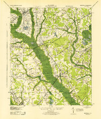
 1946 Sumter1946 Print · USGSSumter and its surrounding lowlands were at a peak of rail and aviation development just after the war. Researchers can trace dozens of rural landmarks, from Pocalla Springs and Swan Lake to the sprawling Shaw Field.
 - 1953 Map of Spartanburg, 1966 Print
 1953 Spartanburg1966 Print · USGSMid-century South Carolina comes into focus through this survey of the Piedmont and the Sand Hills at a time of significant reservoir expansion. Researchers can trace the legacy of industrial transit and resource extraction from the Haile Gold Mine to the rail hubs of the Seaboard Air Line.4 unique versions available
 - 1954 Map of Augusta
 1954 Augusta1954 Print · USGSThe Savannah River valley and South Carolina Midlands are captured here during a period of post-war growth. Researchers can trace the rail-and-river economy through the Southern RR corridor and locate historic settlements like Aiken, Orangeburg, and Sumter.
 - 1957 Map of Sumter East, 1958 Print
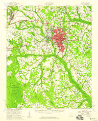
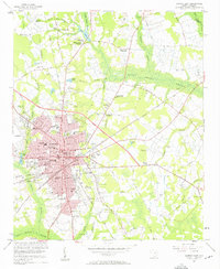 1957 Sumter East1958 Print · USGSSumter was entering a phase of suburban expansion and infrastructure modernization in the late fifties. Genealogists and local historians can trace family names across Rocky Bluff Crossroads, numerous small cemeteries like White-Dick Cem, and landmarks such as MORRIS COLLEGE.3 unique versions available
 - 1957 Map of Ashwood, 1958 Print
 1957 Ashwood1958 Print · USGSThe rural landscapes of Lee and Sumter counties are captured here in the late fifties, during an era of significant agricultural and social transition. Researchers can trace the legacy of New Deal planning at Ashwood, locate family roots at Bethlehem Cems, or follow the Seaboard Air Line through Bishopville.2 unique versions available
 - 1957 Map of Sumter, 1959 Print
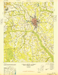
 1957 Sumter1959 Print · USGSSumter at the close of the fifties is a bustling military and educational hub, marked by the expansion of Shaw Air Force Base. Genealogists and local historians can trace rural family churches like Bold Pilgrim Ch and old transport routes including Old Ferry Road.2 unique versions available
 - 1957 Map of Augusta, 1966 Print
 1957 Augusta1966 Print · USGSThe Savannah River and Santee basins are captured here during a period of massive military and industrial expansion in the late fifties. Genealogists can trace family footprints across Four Hole Swamp or near the Savannah River Plant.3 unique versions available
 - 1958 Map of Augusta
 1958 Augusta1958 Print · USGSThe borderlands between Georgia and South Carolina come alive in the 1950s, showing the early footprint of the Savannah River Plant. Genealogists and historians can trace rail-dependent towns and rural landmarks from Orangeburg to the Fort Jackson Military Reservation.
 - 1960 Map of Spartanburg
 1960 Spartanburg1960 Print · USGSThe South Carolina Piedmont and North Carolina borderlands come alive in this mid-century survey of the region between Spartanburg and Columbia. Researchers can trace the Seaboard Air Line railroad and explore landmarks like Anderson Quarry, Lake Murray, and Mount Croghan.2 unique versions available
 - 1961 Map of Augusta
 1961 Augusta1961 Print · USGSThe South Carolina lowcountry and CSRA appear here in the early sixties, during a period of massive military and industrial growth. Researchers can trace the development of the Savannah River Plant or locate legacy landmarks like Nelson Ferry and Magnolia Cemetery.2 unique versions available
 - 1962 Map of Augusta
 1962 Augusta1962 Print · USGSThe South Carolina and Georgia borderlands are seen here in the early sixties, showing the rise of the Savannah River Plant and the expansion of Fort Jackson. Researchers can trace old rail lines like the Southern Railway and find landmarks such as St. Pauls Church or the Santee Canal.
 - 1963 Map of Spartanburg
 1963 Spartanburg1963 Print · USGSMid-century South Carolina comes alive in this survey, showing the rail-linked corridor between the Upstate and the Midlands. Genealogists can trace family lands near old hubs like Union and Lancaster, or along the banks of the Broad River and Pee Dee River.
 - 1964 Map of Spartanburg
 1964 Spartanburg1964 Print · USGSMid-century South Carolina comes alive in this survey of the Piedmont and Upcountry, stretching from the Blue Ridge foothills to the Sandhills. Genealogists and historians can trace the rail-and-river economy through Monarch Mills, Glenn Springs, and the Southern Railway corridor.
 - 1968 Map of Kellytown, 1971 Print
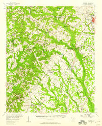
 1968 Kellytown1971 Print · USGSCoastal plain communities in Darlington and Lee counties are captured here in the late sixties, just as the rural landscape was maturing. Researchers can trace family history through sites like Westview Cem, Stokes Bridge, and numerous local churches from Ashland Ch to Mt Elon Ch.
 - 1968 Map of Hartsville South, 1971 Print
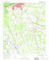 1968 Hartsville South1971 Print · USGSDarlington County's rural crossroads and urban fringes are frozen in time here during the late sixties. Researchers can locate family-named sites like Flinns Crossroads and Polson Crossroads, or trace ancestral ties to St Johns Ch and Magnolia Cem.
 - 1969 Map of Lamar, 1974 Print
 1969 Lamar1974 Print · USGSLamar and its surrounding crossroads communities are captured here in the late sixties, showcasing the rural heart of South Carolina's coastal plain. Genealogists can trace family landmarks and local institutions including Spaulding High Sch, Andrews Millpond, and Zion Ch.
 - 1969 Map of Bishopville East, 1974 Print
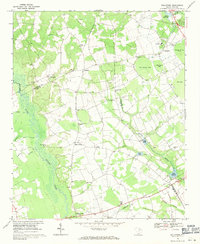
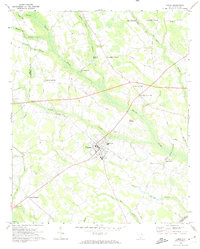
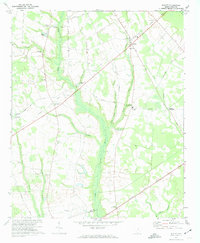
 1969 Bishopville East1974 Print · USGSLee County and the Lynches River basin are captured here in the late sixties as the region balanced its agricultural roots with new infrastructure. Genealogists and local historians can trace family sites at McCutchens Crossroads or locate rural landmarks like St Pauls No 1 Ch and Wisacky.2 unique versions available
 - 1970 Map of Cassatt, 1975 Print
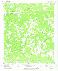 1970 Cassatt1975 Print · USGSIn the early seventies, the rural landscape around Cassatt remained a patchwork of timbered creek bottoms and small-town institutions. Genealogists can trace family roots through numerous sites like Mt Zion Ch, Hickman Sch, and Lockard Cem.
 - 1970 Map of Lucknow, 1975 Print
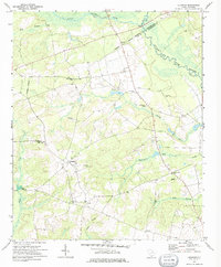 1970 Lucknow1975 Print · USGSThe rural Lee County countryside comes into focus in the early 1970s, showing a landscape shaped by the Lynches River and scattered farming settlements. Genealogists can locate family landmarks like St Matthews Ch, Bethany Cem, and the quiet hamlet of Lucknow.
 - 1973 Map of Elliott, 1974 Print
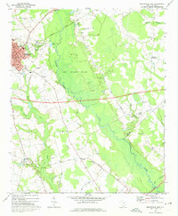
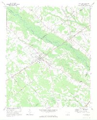
 1973 Elliott1974 Print · USGSIn the early 1970s, the Lee County interior centered on a network of traditional rural hubs and church-centered communities. Researchers can trace family-named sites like Mattie Js Pond or locate historic congregations such as St Sinai Ch and Unionville Ch.2 unique versions available
 - 1973 Map of Lynchburg, 1975 Print
 1973 Lynchburg1975 Print · USGSLynchburg and the surrounding rural communities thrive along the banks of the Lynches River in the early seventies. Genealogists and historians can trace family roots at St Matthews Ch, locate the Hawkins Cem, or follow the path of the Old Stagecoach Road.
Showing maps 1-25 of 109
Top cities of Lee County
Frequently asked questions
- What are the different types of historical maps available for Lee County?
- What is the oldest map of Lee County?
- Where can I purchase historical maps of Lee County for my home or office?
- Where can I download high-res historical maps of Lee County?
- Are there historical topographic maps available for Lee County?
- Is there historical aerial imagery available for Lee County?
- Where are historical maps of Lee County sourced from?