1920s Maps of Lee County, South Carolina
Explore 2 historic maps of Lee County from the 1920s. These maps offer a rare glimpse into what life looked like during the 1920s — showing old roads, neighborhoods, homes, and landmarks that have changed or disappeared over time.
Whether you're researching your family's past, planning a metal detecting trip, or studying how Lee County's landscape evolved across the 1920s, these high-resolution maps are a powerful tool for exploring the history of this region.
- Focus on a specific era: All maps on this page are from the 1920s, giving you a focused view of this time period.
- See what’s changed: Compare century-old streets, trails, and buildings to today's modern landscape using overlays and satellite layers.
- Research with precision: Use these maps for genealogy, historical research, land use analysis, or educational projects.
- View, download, or print: Maps are fully viewable online in high resolution, and can be downloaded or printed for your own records.
Start exploring Lee County's history through authentic maps from the 1920s. This is your window into the past.
Lee County, SC maps
(2)- 1920 Map of Mayesville
 1920 Mayesville1920 Print · USGSThe rural lowcountry of Sumter and Clarendon counties is captured here in the years following World War I, when the Black River and its dense swamps dictated the pace of local life. Researchers can trace early twentieth-century community life through numerous rural landmarks like Brick Church, Tomlinson School, and the path of the Alcolu RR.
 - 1921 Map of Mayesville
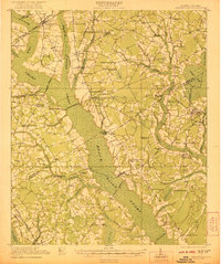 1921 Mayesville1921 Print · USGSThe rural lowcountry of Sumter and Clarendon counties comes into focus during the early 1920s as the railroad era reached its peak. Researchers can trace historic family-named landmarks like Frierson's Store, numerous rural houses of worship such as Beulah Church, and old river crossings like Midway Crossing.3 unique versions available
End of results
Showing maps 1-2 of 2
Top cities of Lee County
Frequently asked questions
- What are the different types of historical maps available for Lee County?
- What is the oldest map of Lee County?
- Where can I purchase historical maps of Lee County for my home or office?
- Where can I download high-res historical maps of Lee County?
- Are there historical topographic maps available for Lee County?
- Is there historical aerial imagery available for Lee County?
- Where are historical maps of Lee County sourced from?