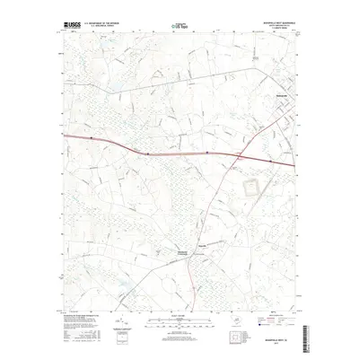
2017 Map of Bishopville West
USGS Topo · Published 2017About this map
Bishopville occupies the northeastern corner of this landscape, where residential streets like S Calhoun St and W Church St meet the outlying rural reaches of Lee County. The terrain is defined by the extensive Scape Ore Swamp, which bisects the region, and a series of water bodies including McGirts Millpond, Denny Pond, and Mary Lees Pond. The drainage network, comprising Beaverdam Cr and Laws Br, influences the placement of the area's smaller settlements and junctions.
Find a feature on this map
115 named features on this map. Tap any name to fly to it.
Don’t see what you’re looking for? This feature index may not catch every label — zoom into the map to look around manually.
Map Details
Editions of this 2017 Bishopville West Map
This is the sole edition of this map. No revisions or reprints were ever made.
Other maps of this area

1941 · Spartanburg
USGS Topo · 1:250,000

1953 · Spartanburg
USGS Topo · 1:250,000

1957 · Ashwood
USGS Topo · 1:62,500

1960 · Spartanburg
USGS Topo · 1:250,000

1963 · Spartanburg
USGS Topo · 1:250,000

1964 · Spartanburg
USGS Topo · 1:250,000

1968 · Kellytown
USGS Topo · 1:24,000
1969 · Bishopville East
USGS Topo · 1:24,000
1970 · Cassatt
USGS Topo · 1:24,000
1970 · Lucknow
USGS Topo · 1:24,000