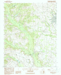
1988 Map of Bishopville West
USGS Topo · Published 1988About this map
Scape Ore Swamp dominates the drainage patterns of this Lee County landscape, its winding course fed by numerous tributaries like Gum Springs Branch and Laws Branch. This late 1980s survey captures the rural character of the area surrounding Bishopville, highlighting a network of small settlements and crossroads such as Manville and Hammetts Crossroads. The terrain is defined by its water resources, with McGrits Millpond in the southwest and Johnsons Pond to the north serving as local landmarks. Human activity is evidenced by scattered infrastructure, including a Lookout Tower and a Landing Strip, while several small Cem labels provide valuable clues for genealogists researching family history in the McGrits vicinity. The map's detailed topography reveals the low-lying nature of the region, where numerous branches like Gin Branch and Cedar Creek weave through the coastal plain.
Find a feature on this map
18 named features on this map. Tap any name to fly to it.
Don’t see what you’re looking for? This feature index may not catch every label — zoom into the map to look around manually.
Map Details
Editions of this 1988 Bishopville West Map
This is the sole edition of this map. No revisions or reprints were ever made.
Other maps of this area

1941 · Spartanburg
USGS Topo · 1:250,000

1953 · Spartanburg
USGS Topo · 1:250,000

1957 · Ashwood
USGS Topo · 1:62,500

1960 · Spartanburg
USGS Topo · 1:250,000

1963 · Spartanburg
USGS Topo · 1:250,000

1964 · Spartanburg
USGS Topo · 1:250,000

1968 · Kellytown
USGS Topo · 1:24,000
1969 · Bishopville East
USGS Topo · 1:24,000
1970 · Cassatt
USGS Topo · 1:24,000
1970 · Lucknow
USGS Topo · 1:24,000