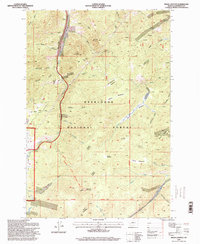
1996 Map of Bison Canyon
USGS Topo · Published 1998About this map
Bison Canyon serves as a central corridor for this high-altitude landscape within the Deer Lodge National Forest during the mid-1990s. The map highlights a long-standing land-use pattern where a Stock Driveway runs parallel to Bison Creek, marking a historical route for moving livestock through the mountains. Industry and recreation intersect here, evidenced by the Eureka Mine and numerous Prospects scattered across the slopes of Sullivan Mountain and Mount Pisgah, alongside modern amenities like the National Recreation Trail. Water sources are vital in this terrain, ranging from the headwaters of the Little Boulder River and Homestake Creek to several high-mountain meadows like Dunks Meadow and Hidden Meadows. This survey provides a look at the interplay between timber management, mining history, and the preserved wilderness near the Butte-Jefferson County line.
Find a feature on this map
48 named features on this map. Tap any name to fly to it.
Don’t see what you’re looking for? This feature index may not catch every label — zoom into the map to look around manually.
Map Details
Editions of this 1996 Bison Canyon Map
This is the sole edition of this map. No revisions or reprints were ever made.
Other maps of this area

1889 · Helena
USGS Topo · 1:250,000

1893 · Helena
USGS Topo · 1:250,000

1899 · Boulder
USGS Topo · 1:125,000

1899 · Helena
USGS Topo · 1:250,000

1903 · Helena
USGS Topo · 1:250,000

1947 · Butte
USGS Topo · 1:250,000

1950 · Jefferson City
USGS Topo · 1:62,500

1954 · Elk Park
USGS Topo · 1:62,500

1954 · Basin
USGS Topo · 1:62,500

1954 · Boulder
USGS Topo · 1:62,500