
1954 Map of Basin
USGS Topo · Published 1956About this map
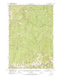
Mining operations and mountain camps dominate this mid-century view of the Continental Divide between Basin and the surrounding national forests. The landscape is dense with specific industrial history, from the Charter Oak Mines and Bullion Mine to more unique labels like the Bluebell Health Mine. This period captures the transition of the region's economy, where active extraction and timber management were the primary drivers of settlement. Small outposts like Hub Camp, Newmans Camp, and Winters Camp are scattered through the high country, while the Great Northern railroad and the Boulder River provide the critical transportation spine through the valley. The presence of the Kading Ranger Station and Bernice Ranger Station indicates the administrative oversight of the Helena National Forest and Deerlodge National Forest as they managed these productive mountain ranges.
Find a feature on this map
100 named features on this map. Tap any name to fly to it.
Don’t see what you’re looking for? This feature index may not catch every label — zoom into the map to look around manually.
Map Details
Editions of this 1954 Basin Map
3 editions found
Other maps of this area

1889 · Helena
USGS Topo · 1:250,000

1893 · Helena
USGS Topo · 1:250,000

1899 · Boulder
USGS Topo · 1:125,000

1899 · Helena
USGS Topo · 1:250,000

1903 · Helena
USGS Topo · 1:250,000

1947 · Butte
USGS Topo · 1:250,000

1950 · Jefferson City
USGS Topo · 1:62,500

1950 · Helena
USGS Topo · 1:62,500

1954 · Elk Park
USGS Topo · 1:62,500

1954 · Boulder
USGS Topo · 1:62,500