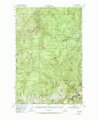
1954 Map of Basin
USGS Topo · Published 1986About this map
Mining operations and high mountain terrain define this 1954 survey of the Deerlodge National Forest region. The settlement of Basin serves as a focal point along the Boulder River, where the Great Northern railroad tracks parallel the river valley. The landscape is heavily marked by the region's mineral history, featuring a dense concentration of named mines such as the Lily-Orphan Boy Mine, Porphyry Dike Mine, and Bullion Mine. These workings are scattered across the slopes of Bison Mountain, Jack Mountain, and Lee Mountain.
Find a feature on this map
96 named features on this map. Tap any name to fly to it.
Don’t see what you’re looking for? This feature index may not catch every label — zoom into the map to look around manually.
Map Details
Editions of this 1954 Basin Map
3 editions found
Other maps of this area

1889 · Helena
USGS Topo · 1:250,000

1893 · Helena
USGS Topo · 1:250,000

1899 · Boulder
USGS Topo · 1:125,000

1899 · Helena
USGS Topo · 1:250,000

1903 · Helena
USGS Topo · 1:250,000

1947 · Butte
USGS Topo · 1:250,000

1950 · Jefferson City
USGS Topo · 1:62,500

1950 · Helena
USGS Topo · 1:62,500

1954 · Elk Park
USGS Topo · 1:62,500

1954 · Basin
USGS Topo · 1:62,500