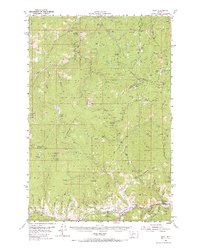
1954 Map of Basin
USGS Topo · Published 1967About this map
Mining operations and timber management define this mid-century landscape where the Deerlodge National Forest and Helena National Forest meet. The settlement of Basin serves as a focal point along the Boulder River, situated on the Great Northern rail line. The map reveals an intensive history of extraction, with numerous named claims such as the Bullion Mine, Lily Orphan Boy Mine, and the Paupers Dream Mine dotting the high-altitude terrain between Jericho Mountain and Jack Mountain.
Find a feature on this map
112 named features on this map. Tap any name to fly to it.
Don’t see what you’re looking for? This feature index may not catch every label — zoom into the map to look around manually.
Map Details
Editions of this 1954 Basin Map
3 editions found
Other maps of this area

1889 · Helena
USGS Topo · 1:250,000

1893 · Helena
USGS Topo · 1:250,000

1899 · Boulder
USGS Topo · 1:125,000

1899 · Helena
USGS Topo · 1:250,000

1903 · Helena
USGS Topo · 1:250,000

1947 · Butte
USGS Topo · 1:250,000

1950 · Jefferson City
USGS Topo · 1:62,500

1950 · Helena
USGS Topo · 1:62,500

1954 · Elk Park
USGS Topo · 1:62,500

1954 · Basin
USGS Topo · 1:62,500