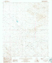
1990 Map of Black Butte
USGS Topo · Published 1990About this map
The Vulture Mountains dominate the northeastern reaches of this Maricopa County landscape, where rugged desert terrain transitions into the wide Hassayampa Plain. This 1990 provisional map records an area defined by extensive mineral exploration and ephemeral drainage systems. Heavy mining activity is evident through the presence of the Lead-Dike Mine, an Open Pit Mine, and numerous scattered prospects and mine dumps.
Find a feature on this map
17 named features on this map. Tap any name to fly to it.
Don’t see what you’re looking for? This feature index may not catch every label — zoom into the map to look around manually.
Map Details
Editions of this 1990 Black Butte Map
This is the sole edition of this map. No revisions or reprints were ever made.
Other maps of this area

1942 · Vicksburg
USGS Topo · 1:250,000

1954 · Phoenix
USGS Topo · 1:250,000

1957 · Phoenix
USGS Topo · 1:250,000

1958 · Phoenix
USGS Topo · 1:250,000

1960 · Phoenix
USGS Topo · 1:250,000

1961 · Vulture Mountains
USGS Topo · 1:62,500

1961 · Big Horn Mts
USGS Topo · 1:62,500

1962 · Belmont Mts
USGS Topo · 1:62,500
1962 · Aguila
USGS Topo · 1:62,500

1969 · Phoenix
USGS Topo · 1:250,000