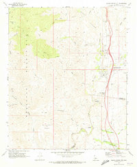
1969 Map of Black Canyon City
USGS Topo · Published 1973About this map
The Agua Fria River carves a path through this high desert landscape, serving as a vital corridor between the Bradshaw Mountains to the west and Black Mesa to the east. By the late 1960s, Black Canyon City and Rock Springs had established themselves as key roadside stops along the major highway north of Phoenix. The map provides a detailed view of the mining and ranching history of the area, featuring the notable Maggie Mine near the river and the Tiptop Mine tucked away in the western canyons. Near the southern bend of the river, the Gillette (Ruins) mark the site of a once-thriving milling town from the silver mining era. The terrain is crisscrossed by several primitive routes, including the Slate Creek Trail and Cottonwood Trail, which navigate the steep drainage systems of Cottonwood Creek and Soap Creek.
Find a feature on this map
34 named features on this map. Tap any name to fly to it.
Don’t see what you’re looking for? This feature index may not catch every label — zoom into the map to look around manually.
Map Details
Editions of this 1969 Black Canyon City Map
This is the sole edition of this map. No revisions or reprints were ever made.
Other maps of this area

1887 · Prescott
USGS Topo · 1:250,000

1892 · Prescott
USGS Topo · 1:250,000

1903 · Bradshaw Mountains
USGS Topo · 1:125,000

1947 · Crown King
USGS Topo · 1:62,500

1947 · Bumblebee
USGS Topo · 1:62,500

1948 · Bumblebee
USGS Topo · 1:63,360

1948 · Crown King
USGS Topo · 1:63,360

1950 · Crown King
USGS Topo · 1:62,500

1950 · Bumblebee
USGS Topo · 1:62,500

1950 · Prescott
USGS Topo · 1:250,000