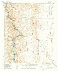
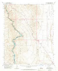
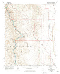
1959 Map of Black Canyon
USGS Topo · Published 1961About this map
The Colorado River carves a deep path through the Eldorado Mountains in this late 1950s survey of the Arizona-Nevada border. This stretch of the river, within the Lake Mead National Recreation Area, shows a transition from the narrow confines of White Rock Canyon to the broader Detrital Valley. The settlement at Willow Beach serves as a focal point for activity, featuring a State Fish Hatchery, a Ranger Sta, and a Gaging Sta.
Find a feature on this map
42 named features on this map. Tap any name to fly to it.
Don’t see what you’re looking for? This feature index may not catch every label — zoom into the map to look around manually.
Map Details
Editions of this 1959 Black Canyon Map
3 editions found
Other maps of this area

1886 · Camp Mohave
USGS Topo · 1:250,000

1886 · Saint Thomas
USGS Topo · 1:250,000

1892 · Camp Mohave
USGS Topo · 1:250,000

1893 · Saint Thomas
USGS Topo · 1:250,000

1926 · Nelson
USGS Topo · 1:96,000

1926 · Bonelli
USGS Topo · 1:96,000

1926 · Boulder Canyon
USGS Topo · 1:96,000

1942 · Camp Mohave
USGS Topo · 1:250,000

1947 · Kingman
USGS Topo · 1:250,000

1948 · Kingman
USGS Topo · 1:250,000