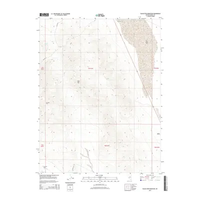
2014 Map of Black Dyke Mountain
USGS Topo · Published 2014About this map
Mina sits at the eastern edge of this high-desert landscape in Mineral County, serving as a primary point of reference along the corridor of Highway 95. The terrain is dominated by the steep rises of the Garfield Hills and the prominent peak of Black Dyke Mtn, which towers over the surrounding basins. This 2014 survey illustrates the stark contrast between the rugged uplands and the expansive, arid stretches of Soda Spring Valley and Garfield Flat.
Find a feature on this map
16 named features on this map. Tap any name to fly to it.
Don’t see what you’re looking for? This feature index may not catch every label — zoom into the map to look around manually.
Map Details
Editions of this 2014 Black Dyke Mountain Map
This is the sole edition of this map. No revisions or reprints were ever made.
Other maps of this area

1909 · Hawthorne
USGS Topo · 1:250,000

1911 · Hawthorne
USGS Topo · 1:250,000

1915 · Hawthorne
USGS Topo · 1:250,000

1948 · Walker Lake
USGS Topo · 1:250,000

1957 · Walker Lake
USGS Topo · 1:250,000

1962 · Walker Lake
USGS Topo · 1:250,000

1964 · Walker Lake
USGS Topo · 1:250,000

1967 · Moho Mountain
USGS Topo · 1:24,000

1967 · Mina NW
USGS Topo · 1:24,000
1967 · Sodaville
USGS Topo · 1:24,000