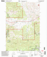
2001 Map of Black Mountain
USGS Topo · Published 2004About this map
Helena National Forest dominates this mountain landscape west of the Montana state capital at the start of the 21st century. The map highlights a complex relationship between natural resource management and regional infrastructure, anchored by the Water Treatment Plant and its associated Settling Basin near Tenmile Creek. The terrain is marked by numerous Prospects and Quarries, indicating a legacy of mineral exploration that parallels the more modern focus on recreation and conservation seen in the Tenmile Environmental Educational Trail. Significant peaks such as Black Mountain and Colorado Mountain define the high ground, while the boundary between Lewis and Clark and Jefferson Counties cuts through the southern portion of the sheet. The presence of Fort Harrison in the northeast corner further connects this wilderness area to established military and civic operations.
Find a feature on this map
29 named features on this map. Tap any name to fly to it.
Don’t see what you’re looking for? This feature index may not catch every label — zoom into the map to look around manually.
Map Details
Editions of this 2001 Black Mountain Map
This is the sole edition of this map. No revisions or reprints were ever made.
Other maps of this area

1889 · Helena
USGS Topo · 1:250,000

1893 · Helena
USGS Topo · 1:250,000

1899 · Boulder
USGS Topo · 1:125,000

1899 · Helena
USGS Topo · 1:62,500

1899 · Helena
USGS Topo · 1:250,000

1903 · Helena
USGS Topo · 1:250,000

1947 · Butte
USGS Topo · 1:250,000

1950 · Jefferson City
USGS Topo · 1:62,500

1950 · Helena
USGS Topo · 1:62,500

1954 · Basin
USGS Topo · 1:62,500