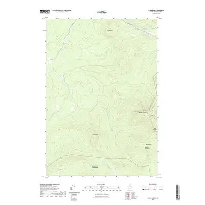
2021 Map of Black Nubble
USGS Topo · Published 2021About this map
Black Nubble and the high ridges of Franklin County dominate this 2021 landscape, illustrating the wilderness of western Maine as it appears in the early 21st century. The Appalachian National Scenic Trail winds through the eastern portion of the map, crossing Crocker Mtn and South Crocker Mtn before continuing toward the Redington Pond Range. This area of Redington Township remains largely defined by its natural drainage systems, including the complex headwaters of Nash Stream, the W Br Nash Stream, and Stoney Brook. The map reveals the limited human footprint in the region, primarily restricted to remote corridors like Navy Rd and the northern boundary of Rangeley. Significant elevations such as Mt Redington and Hedgehog Hill provide a clear view of the high-altitude terrain that has long shaped the recreation and timber history of the Carrabassett Valley region.
Find a feature on this map
17 named features on this map. Tap any name to fly to it.
Don’t see what you’re looking for? This feature index may not catch every label — zoom into the map to look around manually.
Map Details
Editions of this 2021 Black Nubble Map
This is the sole edition of this map. No revisions or reprints were ever made.
Other maps of this area

1928 · Stratton
USGS Topo · 1:48,000

1929 · Phillips
USGS Topo · 1:48,000

1932 · Phillips
USGS Topo · 1:62,500

1932 · Stratton
USGS Topo · 1:62,500

1932 · Kennebago Lake
USGS Topo · 1:48,000

1933 · Rangeley
USGS Topo · 1:48,000

1935 · Kennebago Lake
USGS Topo · 1:62,500

1936 · Kennebago Lake
USGS Topo · 1:62,500

1939 · Rangeley
USGS Topo · 1:62,500

1949 · Jackman
USGS Topo · 1:250,000
Featured Places
- Carrabassett Valley, ME
- Coplin Plantation, ME
- Wyman Township, ME
- Mount Abram Township, ME
- Redington Township, ME