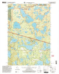
1999 Map of Black Oak Lake
USGS Topo · Published 2005About this map
The Sylvania Wilderness dominates this late-century landscape, preserving a dense network of glacial lakes across the border between Wisconsin and Michigan. Situated within the Ottawa National Forest, the map illustrates a transition from the protected, roadless interior to the more developed edges near the Sylvania Entrance Station. Key features include the Conserve Sch and a local Fish Hatchery, indicating the area's ongoing focus on environmental education and natural resource management.
Find a feature on this map
83 named features on this map. Tap any name to fly to it.
Don’t see what you’re looking for? This feature index may not catch every label — zoom into the map to look around manually.
Map Details
Editions of this 1999 Black Oak Lake Map
This is the sole edition of this map. No revisions or reprints were ever made.
Other maps of this area

1938 · Phelps
USGS Topo · 1:48,000

1946 · Star Lake
USGS Topo · 1:48,000

1950 · Phelps
USGS Topo · 1:48,000

1950 · Star Lake
USGS Topo · 1:48,000

1952 · Watersmeet
USGS Topo · 1:62,500

1952 · Thayer
USGS Topo · 1:62,500

1955 · Starlake
USGS Topo · 1:62,500

1956 · Phelps
USGS Topo · 1:62,500

1958 · Iron River
USGS Topo · 1:250,000

1960 · Iron River
USGS Topo · 1:250,000