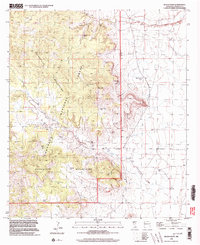
1998 Map of Black Point
USGS Topo · Published 2003About this map
Cloverdale serves as the central focal point for this corner of the Bootheel, situated at the crossroads of ranching and high desert terrain within the Coronado National Forest. This land is defined by the convergence of the Peloncillo Mountains and the Guadalupe Mountains, where the landscape is marked by essential water management features like Buckhorn Tank and Windy Point Tank. The presence of Cem near the Cloverdale settlement and several family-named landmarks, such as Cordy Cowan Tank and Windy Miller Tank, highlights the area's history of homesteading and cattle ranching in a region where water sources like Cloverdale Spring were vital for survival. The topography rises sharply at Kilmer Peak and Black Mountain, providing a stark contrast to the drainage of Foster Draw and the winding course of Cloverdale Creek.
Find a feature on this map
29 named features on this map. Tap any name to fly to it.
Don’t see what you’re looking for? This feature index may not catch every label — zoom into the map to look around manually.
Map Details
Editions of this 1998 Black Point Map
This is the sole edition of this map. No revisions or reprints were ever made.
Other maps of this area

1917 · Chiricahua
USGS Topo · 1:125,000

1918 · Cienega Springs
USGS Topo · 1:62,500

1918 · Animas Peak
USGS Topo · 1:62,500

1919 · Perilla
USGS Topo · 1:125,000

1919 · Chiricahua
USGS Topo · 1:125,000

1920 · Animas Peak
USGS Topo · 1:62,500

1922 · McDonald
USGS Topo · 1:62,500

1940 · Apache
USGS Topo · 1:62,500

1955 · Douglas
USGS Topo · 1:250,000

1958 · Apache
USGS Topo · 1:62,500