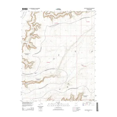
2014 Map of Black Rock Butte
USGS Topo · Published 2014About this map
Canyon De Chelly National Monument dominates this portion of the Defiance Plateau, where centuries of indigenous history are etched into the earth. The landscape is defined by deep, winding drainages like Tseh-Ya-Kin Canyon and Black Rock Canyon, which cut through high formations including Little Mid Mesa and Middle Mesa. This map provides significant archaeological interest by marking the location of the Mummy Cave Ruins near Sheep Point, a site central to the cultural history of the region.
Find a feature on this map
27 named features on this map. Tap any name to fly to it.
Don’t see what you’re looking for? This feature index may not catch every label — zoom into the map to look around manually.
Map Details
Editions of this 2014 Black Rock Butte Map
This is the sole edition of this map. No revisions or reprints were ever made.
Other maps of this area

1892 · Canyon De Chelly
USGS Topo · 1:250,000

1954 · Shiprock
USGS Topo · 1:250,000

1955 · Sonsala Butte 2 SW
USGS Topo · 1:24,000

1955 · Sonsala Butte 4 NW
USGS Topo · 1:24,000

1955 · Sonsala Butte 3 SE
USGS Topo · 1:24,000

1955 · Sonsala Butte 2 SE
USGS Topo · 1:24,000
1955 · Sonsala Butte 3 NE
USGS Topo · 1:24,000
1955 · Sonsala Butte 3 SW
USGS Topo · 1:24,000

1955 · Sonsala Butte 1 SW
USGS Topo · 1:24,000
1955 · Sonsala Butte 4 SW
USGS Topo · 1:24,000