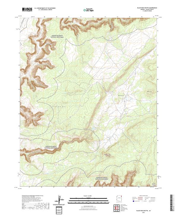
2021 Map of Black Rock Butte
USGS Topo · Published 2021About this map
Canyon De Chelly National Monument encompasses the dramatic, deep-cut drainages of the northern Defiance Plateau, where centuries of wind and water have carved complex landforms into the sandstone. The landscape is defined by its deep canyons, including the iconic Canyon del Muerto and its tributaries like Tseh-Ya-Kin Canyon and Sheep Point Canyon. These natural corridors were central to ancestral life and navigation in this part of Apache County. Prominent high points like Black Rock Butte and White Butte serve as distinct landmarks across the high desert terrain. Reliable water sources, such as Black Rock Spring and Bear Spring, are critical features in this arid environment, often found near the base of mesas like Little Mid Mesa. Local travel is documented by routes like Indian Rte 64 and the Twin Tr E Trl, which follow the natural contours of the plateau.
Find a feature on this map
27 named features on this map. Tap any name to fly to it.
Don’t see what you’re looking for? This feature index may not catch every label — zoom into the map to look around manually.
Map Details
Editions of this 2021 Black Rock Butte Map
This is the sole edition of this map. No revisions or reprints were ever made.
Other maps of this area

1892 · Canyon De Chelly
USGS Topo · 1:250,000

1954 · Shiprock
USGS Topo · 1:250,000

1955 · Sonsala Butte 2 SW
USGS Topo · 1:24,000

1955 · Sonsala Butte 4 NW
USGS Topo · 1:24,000

1955 · Sonsala Butte 3 SE
USGS Topo · 1:24,000

1955 · Sonsala Butte 2 SE
USGS Topo · 1:24,000
1955 · Sonsala Butte 3 NE
USGS Topo · 1:24,000
1955 · Sonsala Butte 3 SW
USGS Topo · 1:24,000

1955 · Sonsala Butte 1 SW
USGS Topo · 1:24,000
1955 · Sonsala Butte 4 SW
USGS Topo · 1:24,000