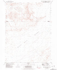
1981 Map of Black Rock Point East
USGS Topo · Published 1981About this map
The Black Rock Range and the Black Rock Desert dominate this landscape on the border of Humboldt and Pershing counties. The survey depicts a stark, high-desert environment where the seasonal course of the Quinn River winds across the playa floor. Evidence of the region’s geothermal activity is marked by Springs (Hot) located near the prominent landmark of Black Rock Point. This terrain illustrates the characteristic Basin and Range topography of northern Nevada, showing the abrupt transition from the steep elevations of the range to the nearly flat expanse of the desert sink. Historically, this area served as a critical waypoint for westward emigrants, who navigated the treacherous desert stretches by following these specific geological features and intermittent water sources.
Find a feature on this map
6 named features on this map. Tap any name to fly to it.
Don’t see what you’re looking for? This feature index may not catch every label — zoom into the map to look around manually.
Map Details
Editions of this 1981 Black Rock Point East Map
This is the sole edition of this map. No revisions or reprints were ever made.
Other maps of this area

1886 · Disaster
USGS Topo · 1:250,000

1886 · Granite Range
USGS Topo · 1:250,000

1889 · Long Valley
USGS Topo · 1:250,000

1893 · Disaster
USGS Topo · 1:250,000

1894 · Granite Range
USGS Topo · 1:250,000

1931 · Lovelock
USGS Topo · 1:250,000

1935 · Lovelock
USGS Topo · 1:250,000

1954 · Vya
USGS Topo · 1:250,000

1955 · Lovelock
USGS Topo · 1:250,000

1958 · Vya
USGS Topo · 1:250,000