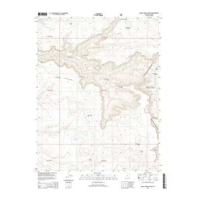
2014 Map of Black Steer Canyon
USGS Topo · Published 2014About this map
Manti-La Sal National Forest dominates the eastern edge of this high-desert landscape, where deep drainages carve through the Dark Canyon Plateau. The terrain is defined by a network of significant canyons, including Black Steer Canyon and Woodenshoe Canyon, which create a complex system of plateaus and flats. Human activity in this isolated region of San Juan County is centered on the remote Dark Canyon Airstrip located near Lower Horse Flats. The map illustrates a stark contrast between the elevated plateau summits and the shadowed depths of Lost Canyon and Gravel Canyon. This survey captures the area in the early 21st century, detailing the transition from the forested mountain boundary to the open grazing lands of Upper Horse Flats.
Find a feature on this map
22 named features on this map. Tap any name to fly to it.
Don’t see what you’re looking for? This feature index may not catch every label — zoom into the map to look around manually.
Map Details
Editions of this 2014 Black Steer Canyon Map
This is the sole edition of this map. No revisions or reprints were ever made.
Other maps of this area

1886 · Henry Mountains
USGS Topo · 1:250,000

1886 · Abajo
USGS Topo · 1:250,000

1892 · Abajo
USGS Topo · 1:250,000

1892 · Henry Mountains
USGS Topo · 1:250,000

1893 · Abajo
USGS Topo · 1:250,000

1935 · Elk Ridge
USGS Topo · 1:96,000

1940 · Elk Ridge
USGS Topo · 1:125,000

1952 · Mouth of Dark Canyon
USGS Topo · 1:62,500

1952 · Natural Bridges
USGS Topo · 1:62,500
1954 · White Canyon 1 NE
USGS Topo · 1:24,000