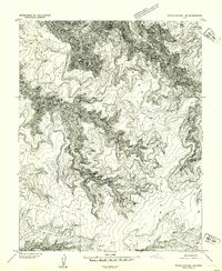
1954 Map of White Canyon 1 NE
USGS Topo · Published 1954About this map
The Colorado River carves through the northern edge of this 1952 topographic survey, marking the boundary between Garfield and San Juan counties. This preliminary edition, derived from 1951 aerial photography, focuses on the labyrinthine drainage systems that feed into the river corridor. Dominating the landscape are high, finger-like mesas such as Bent Point, North Point, and Middle Point, which overlook the deep incisions of Dark Canyon. The intricate contour lines reveal the sheer verticality of the Plateau region and the isolated reaches of Lean-To Canyon and Youngs Canyon. This map serves as a primary record of the canyonlands before modern infrastructure reached this part of the Colorado River basin, capturing a wilderness defined by topographic extremes like Black Point.
Find a feature on this map
12 named features on this map. Tap any name to fly to it.
Don’t see what you’re looking for? This feature index may not catch every label — zoom into the map to look around manually.
Map Details
Editions of this 1954 White Canyon 1 NE Map
This is the sole edition of this map. No revisions or reprints were ever made.
Other maps of this area

1885 · San Rafael
USGS Topo · 1:250,000

1885 · La Sal
USGS Topo · 1:250,000

1886 · Henry Mountains
USGS Topo · 1:250,000

1886 · Abajo
USGS Topo · 1:250,000

1892 · Abajo
USGS Topo · 1:250,000

1892 · Henry Mountains
USGS Topo · 1:250,000

1893 · Abajo
USGS Topo · 1:250,000

1935 · Elk Ridge
USGS Topo · 1:96,000

1940 · Elk Ridge
USGS Topo · 1:125,000

1952 · Mouth of Dark Canyon
USGS Topo · 1:62,500