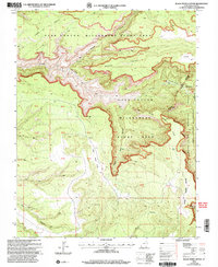
2001 Map of Black Steer Canyon
USGS Topo · Published 2004About this map
The Dark Canyon Wilderness Study Area dominates this remote stretch of southeastern Utah, characterized by intricate drainage systems and dramatic canyon architecture. The landscape is defined by deep incisions like Black Steer Canyon and Youngs Canyon, where the Manti-La Sal National Forest meets rugged high points such as Lean-To Point and Black Point. This 2001 revision highlights a terrain that remains largely unsurveyed, as indicated by the numerous Protracted Blocks like PB 40 and PB 53 that populate the map grid.
Find a feature on this map
50 named features on this map. Tap any name to fly to it.
Don’t see what you’re looking for? This feature index may not catch every label — zoom into the map to look around manually.
Map Details
Editions of this 2001 Black Steer Canyon Map
This is the sole edition of this map. No revisions or reprints were ever made.
Other maps of this area

1886 · Henry Mountains
USGS Topo · 1:250,000

1886 · Abajo
USGS Topo · 1:250,000

1892 · Abajo
USGS Topo · 1:250,000

1892 · Henry Mountains
USGS Topo · 1:250,000

1893 · Abajo
USGS Topo · 1:250,000

1935 · Elk Ridge
USGS Topo · 1:96,000

1940 · Elk Ridge
USGS Topo · 1:125,000

1952 · Mouth of Dark Canyon
USGS Topo · 1:62,500

1952 · Natural Bridges
USGS Topo · 1:62,500
1954 · White Canyon 1 NE
USGS Topo · 1:24,000