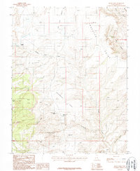
1987 Map of Black Table
USGS Topo · Published 1987About this map
Trachyte Ranch stands as a rare point of human habitation in this 1980s landscape of deep canyons and mesas in Garfield County. The terrain is dominated by the massive Black Table and the jagged elevation of Taylor Ridges, while water sources like Maidenwater Spring and the nearby Maidenwater Reservoir indicate the vital infrastructure required for livestock and survival in this arid environment. The map details an intricate drainage system including Trachyte Creek and the curiously named Black Hole, showing how seasonal runoff has carved the Maidenwater Sands. This survey captures the region after decades of cattle ranching but before significant modern development, preserving the location of family-named landmarks like Speck and traditional water holes such as Hog Spring.
Find a feature on this map
21 named features on this map. Tap any name to fly to it.
Don’t see what you’re looking for? This feature index may not catch every label — zoom into the map to look around manually.
Map Details
Editions of this 1987 Black Table Map
This is the sole edition of this map. No revisions or reprints were ever made.
Other maps of this area

1885 · San Rafael
USGS Topo · 1:250,000

1886 · Henry Mountains
USGS Topo · 1:250,000

1892 · Henry Mountains
USGS Topo · 1:250,000

1952 · Mt Pennell 1 SW
USGS Topo · 1:24,000

1952 · Orange Cliffs 3 SW
USGS Topo · 1:24,000

1952 · Mount Ellen 4 SW
USGS Topo · 1:24,000

1952 · Mt Pennell 1 NE
USGS Topo · 1:24,000

1952 · Mt Hillers
USGS Topo · 1:62,500

1952 · Mt Pennell 1 SE
USGS Topo · 1:24,000

1952 · Mt Pennell 1 NW
USGS Topo · 1:24,000