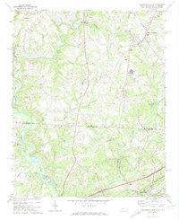
1971 Map of Blacksburg North
USGS Topo · Published 1974About this map
The Broad River and First Broad River converge along the state line in this 1971 survey of the Piedmont, where the rural landscapes of Cleveland Co, North Carolina, and Cherokee Co, South Carolina, meet. The industrial footprint of the era is evident through the Gaston Shoals power development, multiple substations, and Industrial Waste Ponds near Earl. The Southern railroad line serves as a spine for the community of Patterson Springs and smaller railside stops, while the interior is dotted with a dense network of country congregations such as Old Falls Chapel, Youngs Grove Ch, and Maple Springs Ch. On the South Carolina side, the terrain rises toward Whittaker Mountain north of Blacksburg, overlooking a patchwork of creek valleys like Bowens River and Hickory Creek.
Find a feature on this map
58 named features on this map. Tap any name to fly to it.
Don’t see what you’re looking for? This feature index may not catch every label — zoom into the map to look around manually.
Map Details
Editions of this 1971 Blacksburg North Map
This is the sole edition of this map. No revisions or reprints were ever made.
Other maps of this area

1906 · Kings Mountain
USGS Topo · 1:62,500

1908 · Kings Mountain
USGS Topo · 1:62,500

1909 · Gaffney
USGS Topo · 1:62,500

1909 · Lincolnton
USGS Topo · 1:62,500

1911 · Lincolnton
USGS Topo · 1:62,500

1950 · Shelby
USGS Topo · 1:62,500

1953 · Charlotte
USGS Topo · 1:250,000

1954 · Charlotte
USGS Topo · 1:250,000

1960 · Charlotte
USGS Topo · 1:250,000

1962 · Charlotte
USGS Topo · 1:250,000