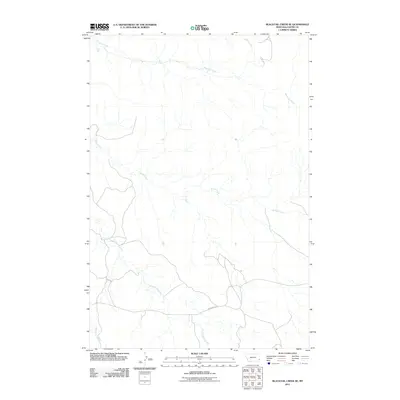
2011 Map of Blacktail Creek SE
USGS Topo · Published 2011About this map
Powderville Rd serves as the primary artery through this pocket of Carter County, traversing a landscape defined by an intricate network of intermittent drainage. The hydrography is dominated by the namesake Blacktail Creek, which winds across the northern reaches of the quadrangle. Further south, the terrain is carved by the converging paths of Spring Creek, South Spring Creek, and Whitetail Creek, illustrating the complex watershed patterns typical of this Montana region. This 2011 survey captures the rural character of the area, showing the relationship between established thoroughfares like Powderville Rd and the natural watercourses like Alkali Creek that dictate the local topography. For those studying the rural infrastructure of southeast Montana, the map details the subtle contours and essential access routes that define land use in this corner of the state.
Find a feature on this map
6 named features on this map. Tap any name to fly to it.
Don’t see what you’re looking for? This feature index may not catch every label — zoom into the map to look around manually.
Map Details
Editions of this 2011 Blacktail Creek SE Map
This is the sole edition of this map. No revisions or reprints were ever made.
Other maps of this area

1954 · Ekalaka
USGS Topo · 1:250,000

1956 · Ekalaka
USGS Topo · 1:250,000

1958 · Ekalaka
USGS Topo · 1:250,000

1965 · Ekalaka
USGS Topo · 1:250,000

1979 · Blacktail Creek NW
USGS Topo · 1:24,000

1979 · Blacktail Creek SE
USGS Topo · 1:24,000

1979 · Board Corral Creek
USGS Topo · 1:24,000

1979 · Blacktail Creek SW
USGS Topo · 1:24,000

1979 · Beaver Flats South
USGS Topo · 1:24,000

1979 · Chalk Buttes
USGS Topo · 1:24,000