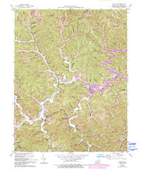
1953 Map of Blaine
USGS Topo · Published 1993About this map
Blaine Creek winds through the heart of this Lawrence County landscape, dictating the development of small communities like Blaine, Houckville, and Cherokee. The topography is defined by sharp ridges and deep hollows, where generations established landmark points such as Clevenger Knob Lookout Tower and Oak Hill. This mid-century survey captures an era when rural life was still deeply localized around neighborhood institutions, including the Springdale Sch, Cando Sch, and the Lower Brushy Creek Ch. The presence of an Oil and Gas Field near the western edge reflects the region's extraction history. Local genealogists will find value in the specific placement of family-named landmarks like Adams Cem and Overda Cem, along with numerous small schools that once served these creek-side hollows.
Find a feature on this map
80 named features on this map. Tap any name to fly to it.
Don’t see what you’re looking for? This feature index may not catch every label — zoom into the map to look around manually.
Map Details
Editions of this 1953 Blaine Map
4 editions found
Other maps of this area

1886 · Prestonsburg
USGS Topo · 1:125,000

1892 · Prestonsburg
USGS Topo · 1:125,000

1903 · Kenova
USGS Topo · 1:125,000

1904 · Kenova
USGS Topo · 1:125,000

1911 · Louisa
USGS Topo · 1:48,000

1913 · Louisa
USGS Topo · 1:62,500

1914 · Inez
USGS Topo · 1:48,000

1915 · Paintsville
USGS Topo · 1:48,000

1916 · Inez
USGS Topo · 1:62,500

1917 · Paintsville
USGS Topo · 1:62,500