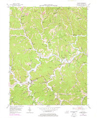
1953 Map of Blaine
USGS Topo · Published 1978About this map
Blaine Creek winds through the heart of this landscape, its deep valleys sheltering tight-knit rural communities during the mid-20th century. This area of Lawrence County is characterized by numerous small mountain schools and family-named landmarks that speak to its settled history. Education and community life centered around local nodes like Rockhouse Sch, Springdale Sch, and the Lower Cains Creek Sch. The industrial presence is marked by a significant Oil and Gas Field and scattered Gas Wells, while the prominent Clevinger Knob is crowned by a Lookout Tower overlooking the forested ridges. Genealogists can trace family footprints through several burial grounds, including Shady Grove Cem and Oak Hill Cem. The map illustrates a transition in land use, showing where traditional valley farming and small settlements like Houckville and Blaine coexist with emerging energy extraction.
Find a feature on this map
103 named features on this map. Tap any name to fly to it.
Don’t see what you’re looking for? This feature index may not catch every label — zoom into the map to look around manually.
Map Details
Editions of this 1953 Blaine Map
4 editions found
Other maps of this area

1886 · Prestonsburg
USGS Topo · 1:125,000

1892 · Prestonsburg
USGS Topo · 1:125,000

1903 · Kenova
USGS Topo · 1:125,000

1904 · Kenova
USGS Topo · 1:125,000

1911 · Louisa
USGS Topo · 1:48,000

1913 · Louisa
USGS Topo · 1:62,500

1914 · Inez
USGS Topo · 1:48,000

1915 · Paintsville
USGS Topo · 1:48,000

1916 · Inez
USGS Topo · 1:62,500

1917 · Paintsville
USGS Topo · 1:62,500