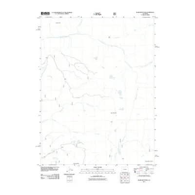
2011 Map of Blair Mountain
USGS Topo · Published 2011About this map
Blair Mountain dominates this high-altitude landscape of the White River Plateau as it appeared in the early 21st century. The terrain is defined by a dense network of alpine hydrology and drainage systems, where the South Fork White River flows eastward, joined by tributaries such as Lost Solar Creek and Park Creek. The map documents a sparsely developed area where human activity is limited to resource extraction and primitive access, evidenced by the Dade Mine near the northern boundary and the presence of Forest Service routes like F S 601. To the south, the flat-topped Clinetop Mesa provides a distinct geographical contrast to the sharp summits of Fowler Peak. Numerous small alpine water bodies are scattered throughout the quadrangle, including Elk Lakes, Blair Lake, and Sixmile Lake, illustrating the typical glacial-carved topography of this Colorado high country.
Find a feature on this map
28 named features on this map. Tap any name to fly to it.
Don’t see what you’re looking for? This feature index may not catch every label — zoom into the map to look around manually.
Map Details
Editions of this 2011 Blair Mountain Map
This is the sole edition of this map. No revisions or reprints were ever made.
Other maps of this area

1906 · Grand Hogback
USGS Topo · 1:125,000

1910 · Grand Hogback
USGS Topo · 1:125,000

1927 · Glenwood Springs
USGS Topo · 1:125,000

1930 · Glenwood Springs
USGS Topo · 1:125,000

1957 · Leadville
USGS Topo · 1:250,000

1959 · Leadville
USGS Topo · 1:250,000

1960 · Leadville
USGS Topo · 1:250,000

1962 · Leadville
USGS Topo · 1:250,000

1964 · Leadville
USGS Topo · 1:250,000
1966 · Meadow Creek Lake
USGS Topo · 1:24,000