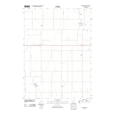
2010 Map of Blairsburg
USGS Topo · Published 2010About this map
Blairsburg and Kamrar serve as the primary hubs of this agricultural landscape in central Iowa. This 2010 survey illustrates the highly organized section-line road network and the significant role of hydraulic engineering in the region's farming history, with features such as Ditch Number 166 and the Branch Loop Ditch designed to manage the local watershed. Family and community heritage are anchored by sites like the Blairsburg Cemetery, Liberty Center Cemetery, and the Presbyterian Cemetery, which sit alongside established civic locations including the Blairsburg Post Office and Kamrar Post Office. To the north, the small settlement of Stonega marks another point of habitation. The South Skunk River enters the frame in the east, providing a natural contrast to the grid-heavy development of the surrounding prairie.
Find a feature on this map
36 named features on this map. Tap any name to fly to it.
Don’t see what you’re looking for? This feature index may not catch every label — zoom into the map to look around manually.
Map Details
Editions of this 2010 Blairsburg Map
This is the sole edition of this map. No revisions or reprints were ever made.
Other maps of this area

1954 · Waterloo
USGS Topo · 1:250,000

1955 · Waterloo
USGS Topo · 1:250,000

1978 · Blairsburg
USGS Topo · 1:24,000

1978 · Woolstock
USGS Topo · 1:24,000

1978 · Ellsworth
USGS Topo · 1:24,000

1978 · Webster City
USGS Topo · 1:24,000

1978 · Sheldon Creek
USGS Topo · 1:24,000
1978 · Stanhope
USGS Topo · 1:24,000

1978 · Jewell
USGS Topo · 1:24,000

1978 · Clarion SW
USGS Topo · 1:24,000