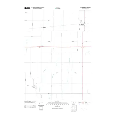
2013 Map of Blairsburg
USGS Topo · Published 2013About this map
The settlement of Blairsburg anchors the northeast corner of this Hamilton County landscape, situated where the local road network converges around the Reinicker railroad line. This 2013 survey illustrates a highly engineered agricultural environment, defined by an extensive system of drainage infrastructure including Ditch Number 265, Ditch Number 266, and the Loop Branch Ditch. These man-made channels support the prairie farmland surrounding the headwaters of the S Skunk River. To the southwest, the town of Kamrar is mapped with its own distinct street grid, while the community of Stonega serves as a secondary rail-side waypoint. The map clearly documents the modern transportation corridor where Highway 20 bisects the township, providing a detailed record of the intersections and rural property access points like Stonega Dr and Neely Ave as they existed in the early 21st century.
Find a feature on this map
47 named features on this map. Tap any name to fly to it.
Don’t see what you’re looking for? This feature index may not catch every label — zoom into the map to look around manually.
Map Details
Editions of this 2013 Blairsburg Map
This is the sole edition of this map. No revisions or reprints were ever made.
Other maps of this area

1954 · Waterloo
USGS Topo · 1:250,000

1955 · Waterloo
USGS Topo · 1:250,000

1978 · Blairsburg
USGS Topo · 1:24,000

1978 · Woolstock
USGS Topo · 1:24,000

1978 · Ellsworth
USGS Topo · 1:24,000

1978 · Webster City
USGS Topo · 1:24,000

1978 · Sheldon Creek
USGS Topo · 1:24,000
1978 · Stanhope
USGS Topo · 1:24,000

1978 · Jewell
USGS Topo · 1:24,000

1978 · Clarion SW
USGS Topo · 1:24,000