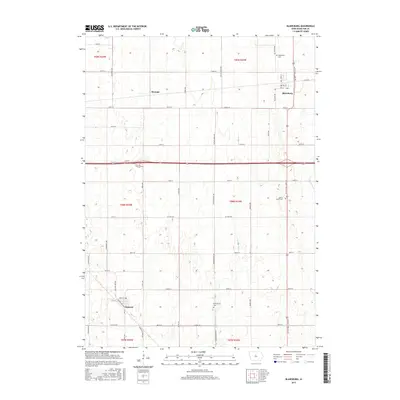
2015 Map of Blairsburg
USGS Topo · Published 2015About this map
The agricultural landscape of Hamilton County is defined by its rectilinear grid and the persistent settlements of Blairsburg and Kamrar. At the northern edge of the survey, the village of Blairsburg is flanked by the Blairsburg Cem and sits near the intersection of the regional road network, while Stonega represents a smaller, more localized point of interest further west. The southern portion of the map is anchored by the town of Kamrar, where a more dense street plan including Railway Ave and Hill St suggests its historic orientation toward rail transportation.
Find a feature on this map
48 named features on this map. Tap any name to fly to it.
Don’t see what you’re looking for? This feature index may not catch every label — zoom into the map to look around manually.
Map Details
Editions of this 2015 Blairsburg Map
This is the sole edition of this map. No revisions or reprints were ever made.
Other maps of this area

1954 · Waterloo
USGS Topo · 1:250,000

1955 · Waterloo
USGS Topo · 1:250,000

1978 · Blairsburg
USGS Topo · 1:24,000

1978 · Woolstock
USGS Topo · 1:24,000

1978 · Ellsworth
USGS Topo · 1:24,000

1978 · Webster City
USGS Topo · 1:24,000

1978 · Sheldon Creek
USGS Topo · 1:24,000
1978 · Stanhope
USGS Topo · 1:24,000

1978 · Jewell
USGS Topo · 1:24,000

1978 · Clarion SW
USGS Topo · 1:24,000