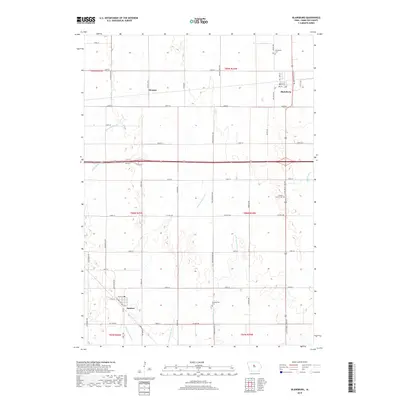
2018 Map of Blairsburg
USGS Topo · Published 2018About this map
The town of Kamrar and the community of Blairsburg anchor this Hamilton County landscape, illustrating the grid-based development typical of the Iowa plains. The transition of the natural prairie into highly productive agricultural land is evidenced by the complex network of drainage systems, including Ditch Number 206, Ditch Number 266, and the Loop Br Ditch. These man-made channels support the surrounding farmsteads while feeding into the S Skunk River to the east. Genealogists can locate several local burial grounds, such as Blairsburg Cem, Liberty Center Cem, and the Presbyterian Cem located south of the small settlement of Stonega. The map reveals the persistence of rural township structures through the township and range identifiers, while the modern highway infrastructure provides a contrast to the secondary roads like Little Wall Lake Rd and Poplar Grove Ave.
Find a feature on this map
52 named features on this map. Tap any name to fly to it.
Don’t see what you’re looking for? This feature index may not catch every label — zoom into the map to look around manually.
Map Details
Editions of this 2018 Blairsburg Map
This is the sole edition of this map. No revisions or reprints were ever made.
Other maps of this area

1954 · Waterloo
USGS Topo · 1:250,000

1955 · Waterloo
USGS Topo · 1:250,000

1978 · Blairsburg
USGS Topo · 1:24,000

1978 · Woolstock
USGS Topo · 1:24,000

1978 · Ellsworth
USGS Topo · 1:24,000

1978 · Webster City
USGS Topo · 1:24,000

1978 · Sheldon Creek
USGS Topo · 1:24,000
1978 · Stanhope
USGS Topo · 1:24,000

1978 · Jewell
USGS Topo · 1:24,000

1978 · Clarion SW
USGS Topo · 1:24,000